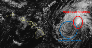
Former Tropical Storm Gilma weakened east of Hawaii on Thursday. At 5:00 p.m. EDT on Thursday the center of Tropical Depression Gilma was located at latitude 20.3°N and longitude 151.7°W which put the center about 225 miles (360 km) east of Hilo, Hawaii. Gilma was moving toward the west-northwest at 12 m.p.h. (19 km/h). The maximum sustained wind speed was 35 m.p.h. (55 km/h) and there were wind gusts to 45 m.p.h. (75 km/h). The minimum surface pressure was 1010 mb.
An upper level low west of California was producing strong southwesterly winds that blew toward the top of former Tropical Storm Gilma. Those winds caused strong vertical wind shear. The strong wind shear blew the middle and upper parts of Gilma;s circulation to the northeast of the lower portion of the circulation.
The lower portion of the circulation around Tropical Depression Gilma consisted primarily of bands of showers and low clouds. Thunderstorms were still being produced in the middle level circulation which was northeast of the low level center of Gilma.
Tropical Depression Gilma will move through an environment that will be unfavorable for intensification during the next 24 hours. Gilma will move over water where the Sea Surface Temperatures are near 24°C. The upper level low west of California will continue to produce southwesterly winds that will blow toward the top of Gilma’s circulation. Those winds will cause strong vertical wind shear. Tropical Depression Gilma is likely to continue to weaken during the next 24 hours.
Tropical Depression Gilma will move around the southern side of a subtropical high pressure system over the Eastern and Central North Pacific Ocean. The high pressure system will steer Gilma toward the west-northwest during the next 24 hours. On its anticipated track, Tropical Depression Gilma pass just north of Hawaii on Friday.
The circulation in the western side of Tropical Depression Gilma could enhance the northeasterly trade winds. Stronger trade winds could cause more rain to fall on the northeastern slopes of the Hawaiian Islands.
Elsewhere, Tropical Storm Hone was spinning southeast of Midway Island. At 5:00 p.m. EDT on Thursday the center of Tropical Storm Hone was located at latitude 21.4°N and longitude 172.4°W which put the center about 565 miles (910 km) southeast of Midway Island. Hone was moving toward the west-northwest at 7 m.p.h. (11 km/h). The maximum sustained wind speed was 40 m.p.h. (65 km/h) and there were wind gusts to 50 m.p.h. (80 km/h). The minimum surface pressure was 1006 mb.
